Category Archives: Travel

WRIAD: White Rim in a Day

Summary

The White Rim Trail is SW of Moab Utah. It follows the Colorado River SW to its junction with the Green River, then NW up the Green River, making a rough “V” shape, then a mix of dirt & paved roads connect the top of the V. It makes a loop measuring 100 miles, about 8000′ of cumulative climb. The trail ranges from simple dirt/rock, to sand, to rugged steep technical with big rocks. Along the route there is no food, water or services. And mostly no cell/mobile coverage.

Most bicycle tours take 3-4 days to do this trail, supported with 4WD vehicles providing food, water and shelter. It is possible to ride it in a single day, but it’s a big physical effort that also takes some planning. It helps to have a gung-ho friend named Stefan to convince you to ride it with him.

Stefan rode WRIAD solo in Oct 2020, and he and I rode it together in Oct 2022. This describes what it was like and how we prepared for it.

Pics here: http://mclements.net/Moab-202210/

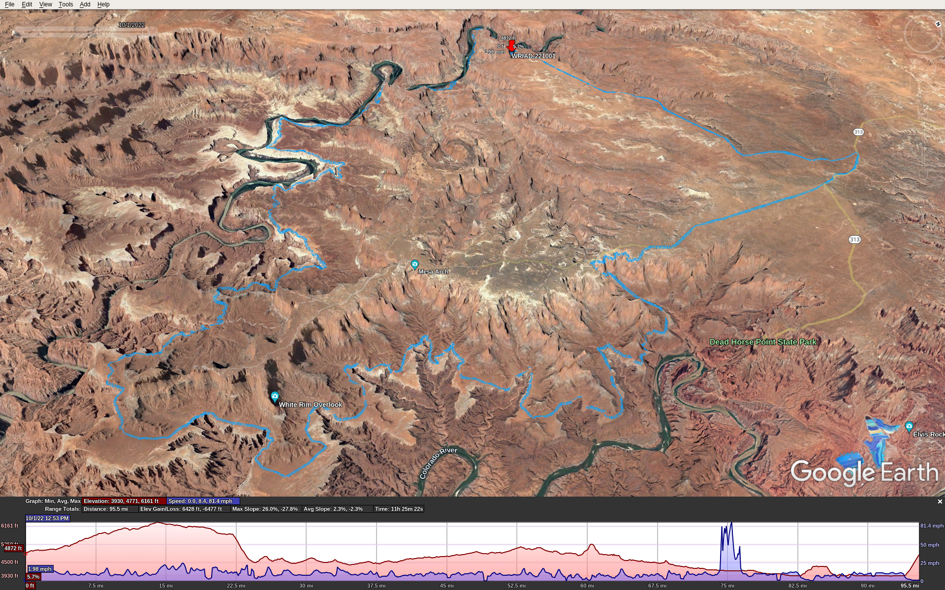
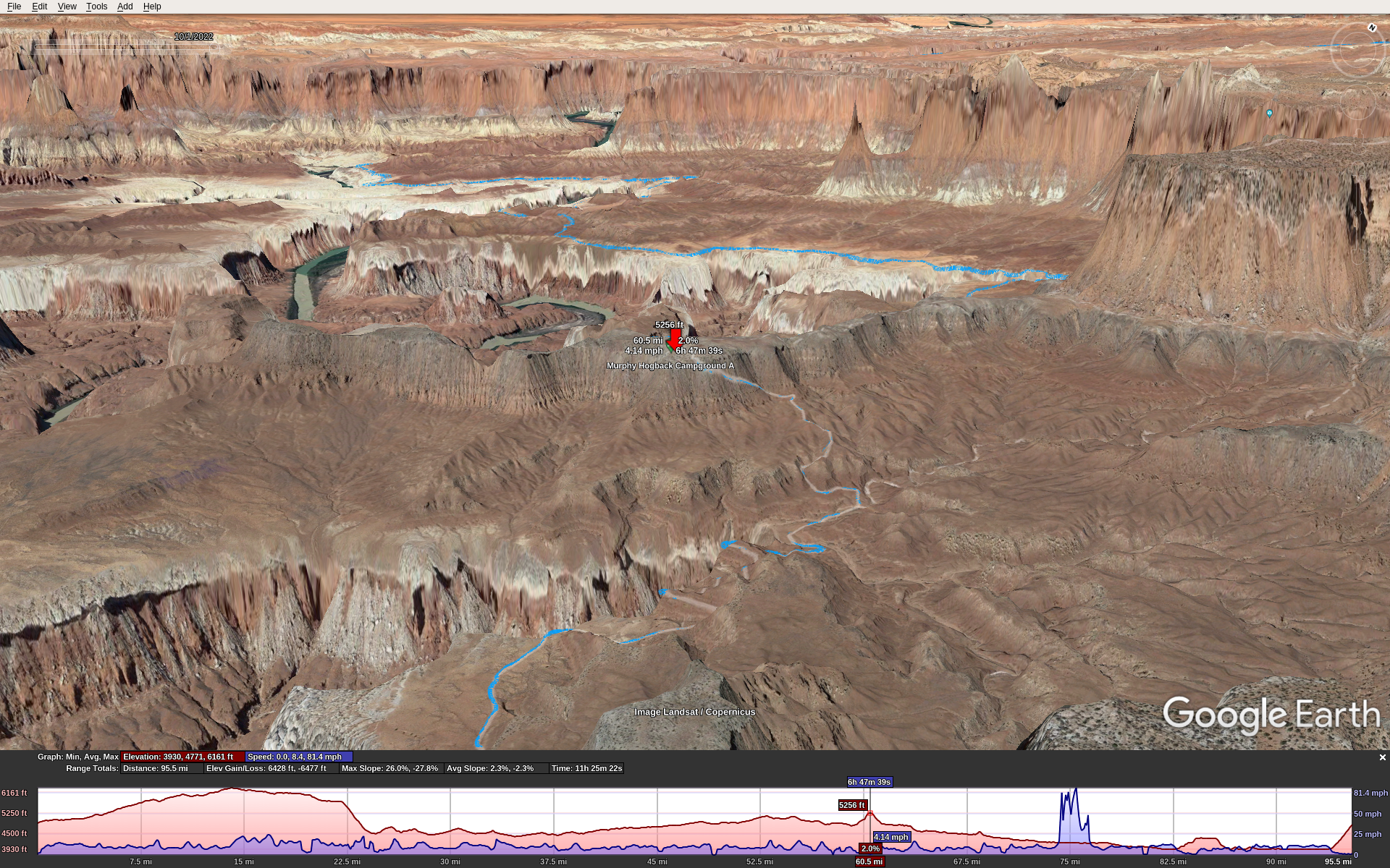
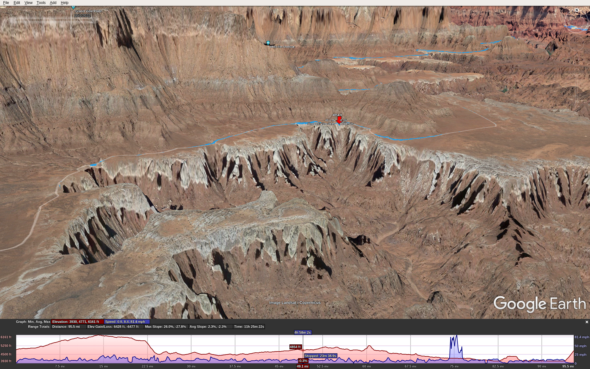
Here’s the GPX track overlaid with Google Earth, which underestimates the mileage and elevation because it over-smooths and simplifies the track. The red flag is our start/end point. The spike in speed around mile 75 is a GPS glitch.

Preparation

I’ve done some big tough MTB rides over the years. La Ruta, Kokopelli’s Trail, OTGG, and others of Stefan’s and my own devising. From a fitness perspective I knew what to expect. It takes several months to a year of serious training to get into the best physical fitness you can. You’re going to be pedaling for 10-12 hours over rugged terrain, miles of tire-sucking sand, and incredibly steep grades (> 25%) that make its 100 miles feel more like a 200 mile road ride.

The best time to ride WRIAD is in spring or fall. This means near the equinox, so you’ll have about 12 hours of daylight.

You need a day-use permit that you can get a day or two in advance, cost about $6. And you need to pay another $15 to enter the national park.

Plan on 11-12 hours total if you stop only once or twice during the ride. That means enough food and water to carry you through. Everyone is different; here’s what worked for me. I had 224 ounces of water: two 100 oz camelback bladders, plus a 24 oz. water bottle. I used all but 12 ounces of it. For food, bring some real food for lunch (sandwich, burrito, etc.) and about 240 cals per hour to eat while you’re riding. Have this food ready to eat while riding because if you stop to eat every hour, you might not finish the ride in daylight.

Have a bike that you trust, proven to stand abuse. A bike mechanical failure that strands you along the trail can keep you there overnight and become a life threatening situation. Make sure the entire drivetrain, axles, etc. are new and fresh. Several sections of the trail are too rugged for a gravel bike. You will need a true mountain bike, hard-tail or full suspension, with knobby or semi-knobby tires at least 2″ or 50mm wide. I used Maxxis Ardent Race, 2.2″ / 57mm and they were great. Anything narrower wouldn’t work, anything wider would make a hard ride even harder.

Clockwise or Counterclockwise?

This is a common question. Both ways are doable. Either way you go, you’ll descend into the canyon then climb back out again. These two points are Shafer on the NE side and Mineral Bottom on the NW side.

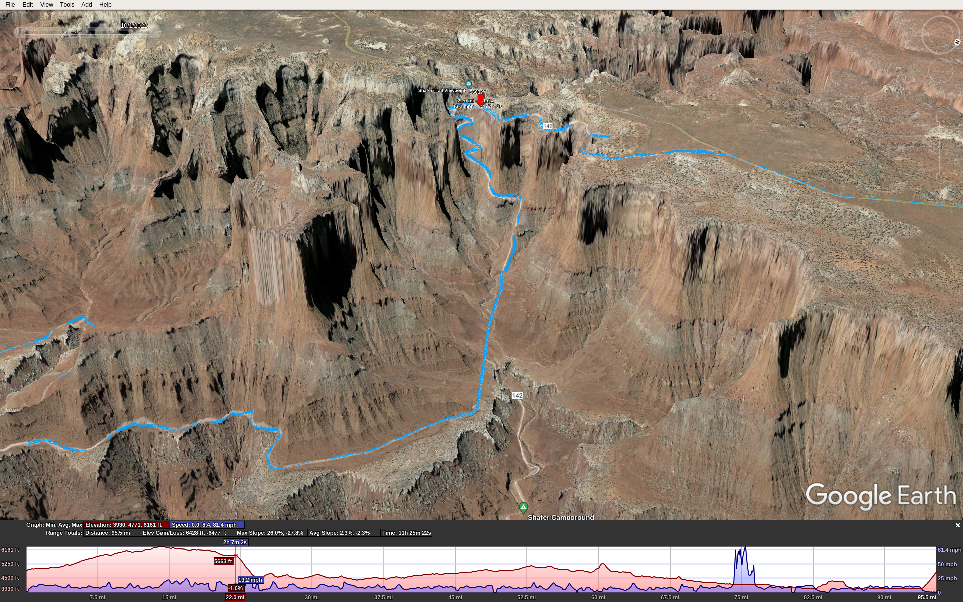
Here’s the Shafer grade. Red marker is poised at the top.

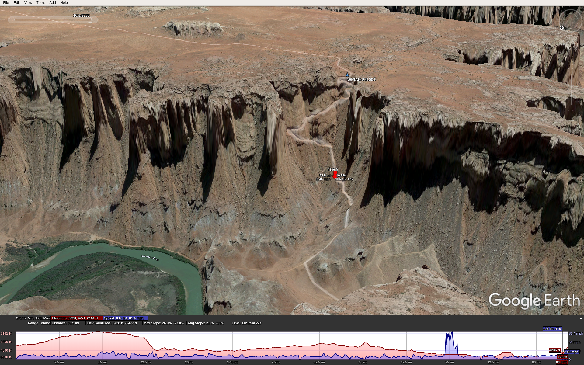
Here’s the Mineral Bottom grade. Red marker is half-way up, blue marker is our start/end point.

Also, along the trail in the canyon are 2 big notable climbs, each close to 1000′ with some sections too steep to ride. So no matter which way you go, you’ll have 3 very big climbs, in addition to the constant up and down of the trail.

Climb 1, Murphy Hogback, the up side:

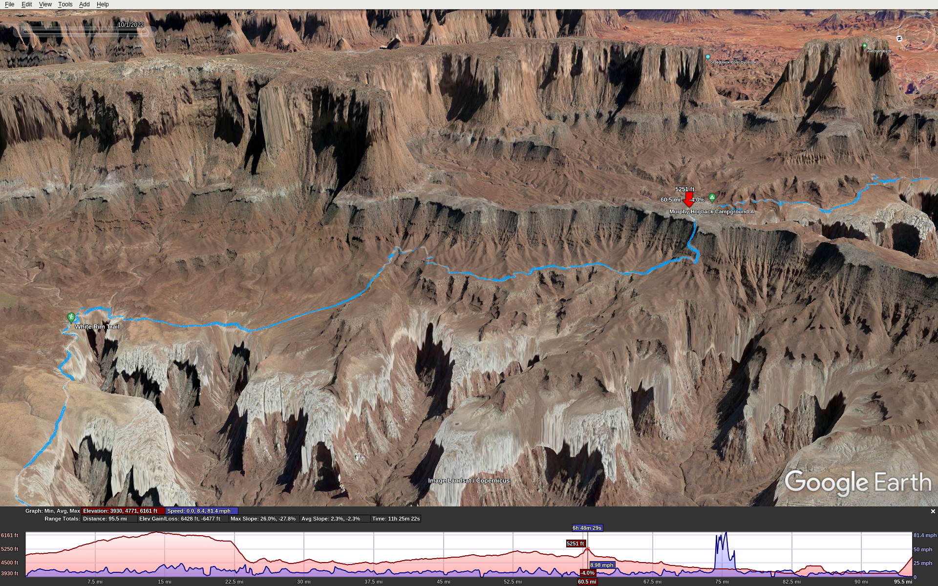
Climb 1, Murphy Hogback, the down side:

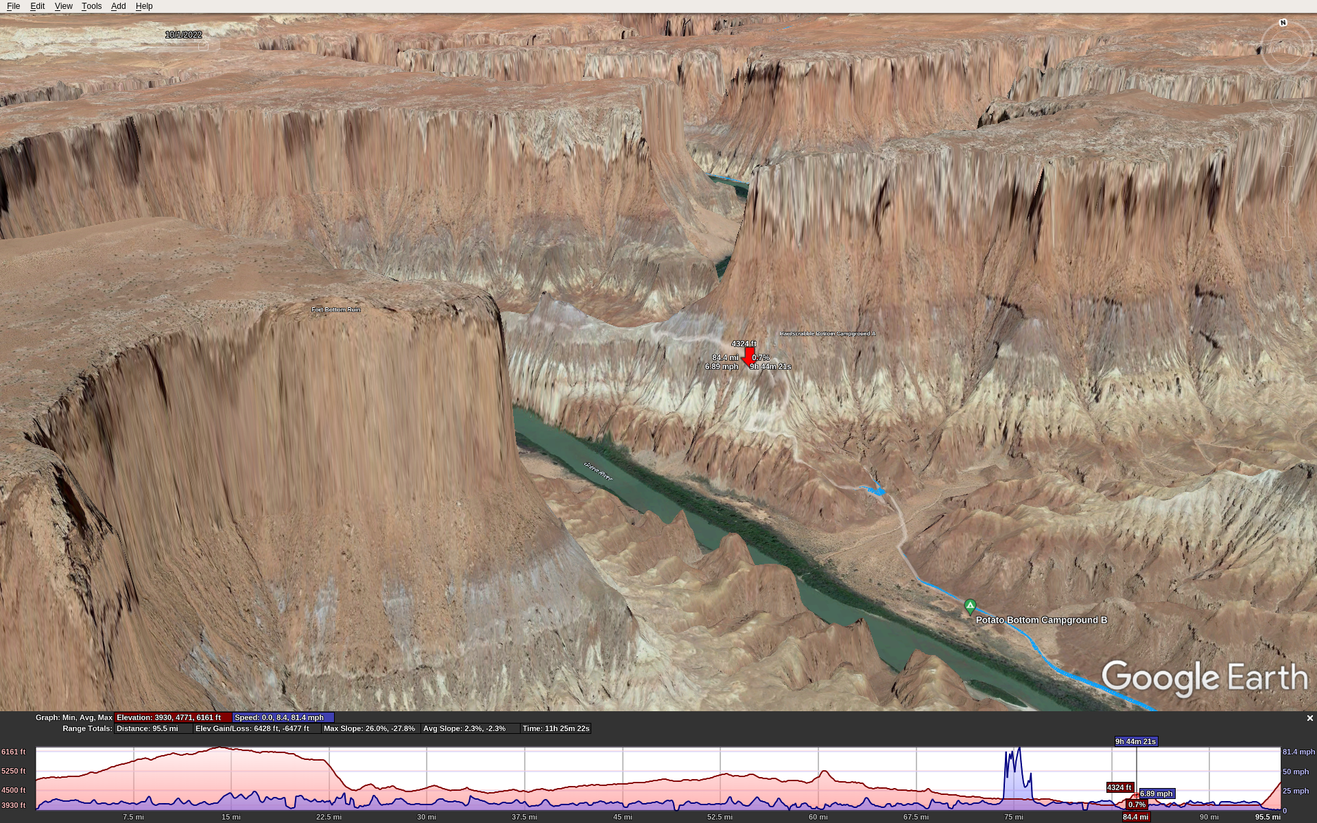
Climb 2, Hardscrabble Bottom, the up side:

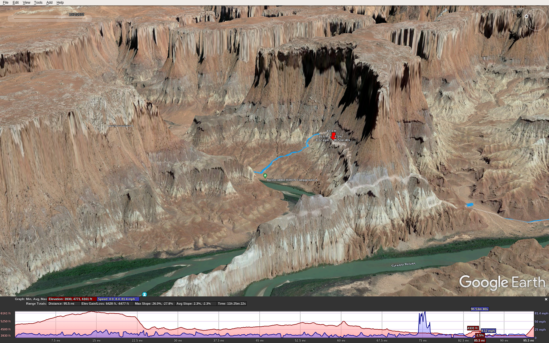
Climb 2, Hardscrabble Bottom, the down side:

We went clockwise starting from the NW corner of the route: the parking lot and toilet just at the top of the Mineral Bottom Climb. This means starting with a 12 mile dirt/gravel road ride that gradually climbs about 1200′, then turning right onto the paved road that runs into the park. Total distance to the Shafer descent where you enter the canyon trail is about 20 miles. Then you ride another 79 miles along the White Rim Trail, and then climb up Mineral Bottom back to where you started. It’s about 1000′ in 1 mile.

The east half of the ride is easier than the west half. It’s just a bit flatter, less sand, less rugged & technical. So the drawback of the clockwise route is that the toughest riding is in the second half of the ride. However, the Mineral Bottom climb, as tough as it is, isn’t quite as rugged or long as the Shafer climb.

Getting There

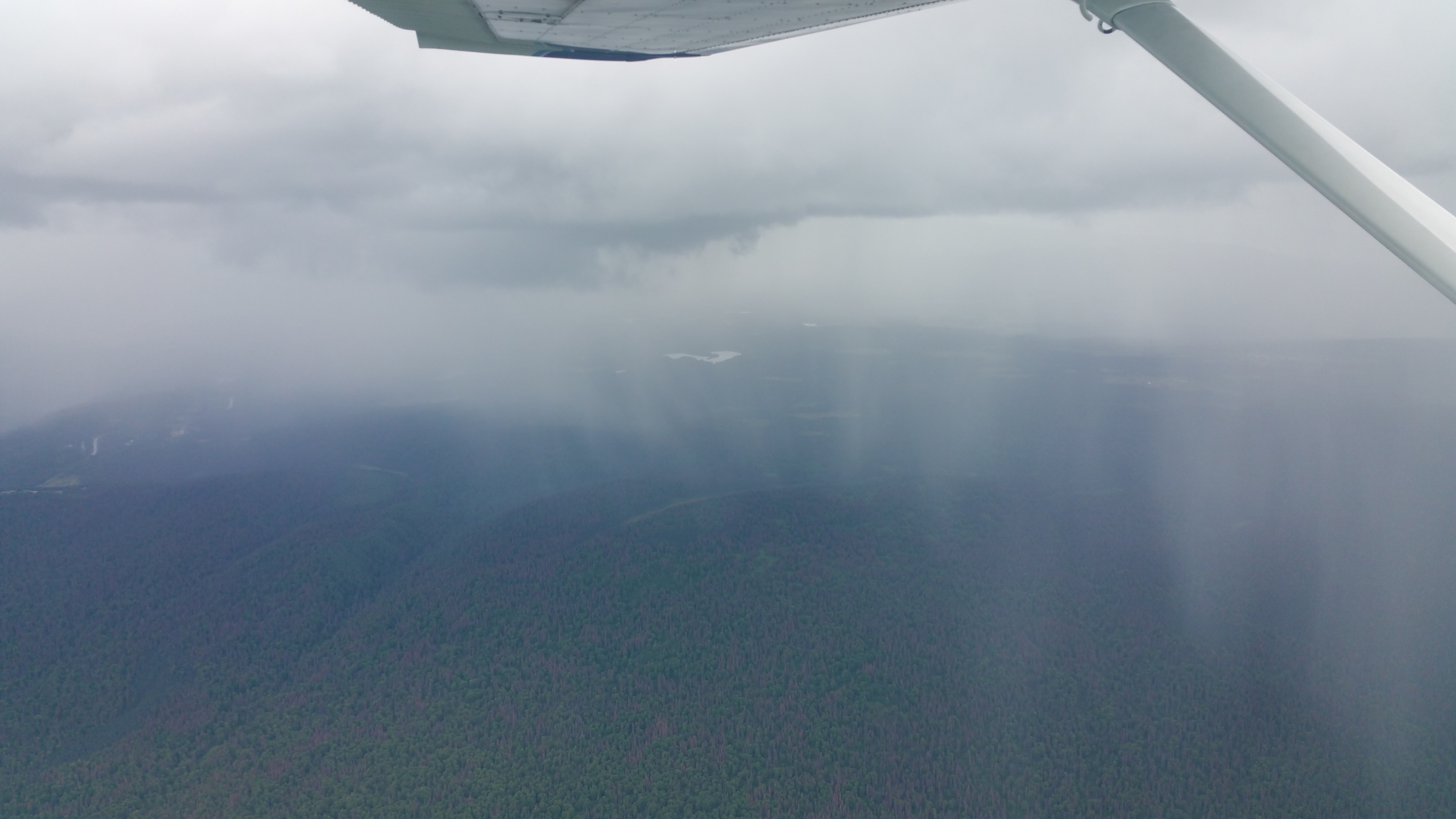
I flew from Seattle into Moab in my C-172, Stefan drove from Boulder, and we met at the Moab airport KCNY. We stayed at the Moab Apache Inn. It’s not fancy, but it’s a good place with truly excellent service/management.

Sunrise was at 6:45, so that’s when we started. Temps in early Oct were in the mid-high 50s at the start and got into the 70s during the day. This was fortunate!

The Ride

Our start point was at 4800′ MSL. The way we rode, we started along the dirt/gravel road on a long gradual climb. This was nice because it was cool out and the climbing kept us warm so we didn’t need to bring jackets that we would only doff later and carry all day. At mile 12 we reached the paved road (Hwy 313) which is near the peak elevation of about 6000′. We turned S towards the park. After entering the park, a short distance more put us at the top of the Shafer grade with 20 miles on the odometer.

The Shafer descent is just rugged and steep enough to keep you on your toes. If you slide out and miss a turn it could lead to a fatal fall. It was no problem on my full suspension bike but you would not want a gravel bike or skinny tires. It’s incredibly scenic. A short distance and about 1000′ of descent later, you’re in the canyon on the trail. To call it scenic is a grave understatement. It’s stunning.

Here (red marker) is where we had lunch, around mile 55:

For the next 43 miles or so you ride along the rims of canyons, weaving in and around following the contours. Then you reach one of the big steep climbs at Murphy Hogback Canyon. Some parts of this are too steep to ride. It just goes up and up. The top levels off for less than a mile then you go down an equally steep opposite side.

The next 20 miles or so is a gradual downhill, but don’t let the word “downhill” fool you. It’s got long sections of soft sand which sucks down tires, forcing you to pedal hard at slow speed despite the downhill grade.

At this point I encountered nutrition difficulties. I brought Kind bars to eat throughout the day, because they are low sugar and worked great for me in all-day rides over the years. Yet starting around mile 65 I couldn’t keep them down; as I ate them I got a strong urge to barf them back up, so I had to stop eating them. Fortunately, Stefan had some spare Fritos and I had no problem eating those. I never considered chips to be an ultra-endurance food, but sometimes during adversity we learn new things about ourselves. In hindsight it makes sense: Fritos are simple carbs (but no sugar), plenty of salt, and calorie dense. I don’t think the problem was electrolyte loss because I had Nuun mineral tablets in all my water.

Then you reach the second big climb, Hardscrabble Bottom. It’s every bit as tough as the Murphy Hogback climb, ultra steep with some sections too steep to ride. Ride along the top for about 2 miles or so, rolling up and down varying from decent to rough technical conditions. Then back down the other side takes you to around 4000′ MSL about the level of the Green River.

Now ride along a decent quality trail following the Green river for about 15 miles or so, mostly flat. Then around mile 99 you reach the right turn to go up Mineral Bottom. Only 1 mile to go, but it’s very steep, nearly 1000′ climb.

At the end of the ride I didn’t feel right – eating or drinking would have triggered vomiting. I think it was temporary over-exertion because over the 1st post-ride hour I slowly sipped 12 oz of water and kept it down, and over the next hour I felt fine. An hour later we ate a big dinner in town, no problem.

Conclusion

WRIAD was a bucket-list ride for me. The preparation and execution consumed nearly a year of my life. I got into the best physical condition I’ve ever been, similar to doing La Ruta over 20 years ago. Even so, it was one of the toughest rides I’ve ever done, if not the very toughest. I’m pretty sure I’ll never do it again, but big rides like this come with satisfaction and confidence equal to what you put into them. Thanks Stefan for suggesting this one! It was an epic adventure.

Schwalbe G-One Allround Tire Review & Road Test (Garbage!)

In early 2020 I was preparing to ride the Oregon Trail Gravel Grinder, a 5-day stage ride based in Sisters, OR. My road bike won’t make that gravel ride, and with 7 bikes in the garage I did not want yet another bike. So I decided to ride it on my mountain bike. However, the heavy knobby tires that work so well on rough terrain are not optimal for gravel. They are just not efficient enough, especially for doing 350 miles in 5 days.

Note: these are tubeless wheels, Reynolds Carbon AR, size 27.5″ / 650 / 584.

Gravel rides are a “thing” now, so there are lots of tire options. After reading a bunch of reviews I opted for Schwalbe G-One Allround tires. They make 2 sizes for my bike: 40-584 and 57-584 (note: 584, 650 and 27.5″ are all the same wheel size, just different ways of measuring it). One seemed a bit too skinny (40mm = 1.6″), the other a bit too fat (57mm = 2.24″). I wasn’t sure which would be best so I ordered a set of each.

First, I installed the wide ones. They installed and sealed neatly without the need for my compressor. Rode them around the block, pumped them up to 5 PSI below max. They held pressure overnight and I rode them the next day on a gravel road (John Wayne Trail from Rattlesnake Lake toward Snoqualmie Tunnel). Ran about 35 PSI rear, 30 PSI front. They did fine and I could feel how much lighter and faster they were.

Failure the First

Next ride, I hit the Snoqualmie Valley Trail. About 40 miles in, I could hear the rear wheel losing air. It had a puncture with sealant spraying out. The sealant eventually did its job and I finished the ride (10 more miles) and made it home. I inspected the tire from the outside, there was no obvious damage, so I removed the valve stem and added another ounce of sealant to replace what it had lost.

Failure the Second

The OTGG was cancelled due to COVID, so I flew out to Moab to meet Stefan for some biking. On day 1, riding the easy Bar M Loop Trail, the front tire flatted. Sealant spewed out, then after a long moment it did its job. I used my hand pump to replace some of the lost pressure and we finished the ride.

Failure the Third

Now it was 2021 and I was preparing to ride the Cascade Gorge Grinder that had been cancelled the prior year. So I installed the skinny G-One Allround tires. At least, I tried to. After completing the first and inflating it to 5 PSI below max pressure, I set it aside to work do the second. About 10 minutes later, BANG! The tire I had set aside blew off the rim. Upon inspection, the bead had ruptured internally without any exterior evidence of cuts or damage. I use only smooth plastic tire “irons”. Chalk it up to manufacturing defect.

So I reinstalled the fat ones.

Failure the Fourth

Next ride, I went out on the same pavement that I ride my road bike. After a few miles I heard the familiar dreaded sound of the rear tire losing pressure and spewing sealant. This time, it never sealed. I stopped and rotated the rear wheel so the puncture was at the bottom so the sealant could gather there. All the sealant (I use 2 full ounces) spewed out and it went completely flat. I had to walk home.

Conclusion

Schwalbe’s G-One Allround tires are so fragile they repeatedly puncture, even on paved roads that my road bike can handle with 700×23 tires. They seem to impair sealant from doing its job, and I also encountered a manufacturing defect that caused one to blow off the rim even when seated and sealed, and below its max recommended pressure.

Needless to say, I’m never buying Schwalbe tires again. I’ve never had these problems with Maxxis tires (knock on wood!).

Note: I’m now using Maxxis Ramblers size 47-584 on this bike, for gravel rides. Fingers crossed!

For knobbies I’ve used Maxxis Ardents, and now use the DHF / DHR combo. Both have been great; good traction, easy installation and no flats. Of course, they’re heavy with higher rolling resistance. But when you need rugged knobbies, those aspects are less important and these are great tires.

Road Biking: Vashon Island

Vashon Island is a fun road bike ride. It’s rural and scenic, and hilly making a great workout. Here you will find suggestions to make this ride a smooth experience.

Ride Overview

The full ride is about 42 miles with 3900′ of climbing. The hills are steep and there’s lots of them, making it feel more like a 50-60 mile ride. Here is a GPX of the full route. Here is a picture:

On the route you can see 2 black dots. These are decision points to change the ride.

Decision point 1: about mile 13; whether to ride down to the Tahlequah ferry terminal at the S tip of Vashon Island. This is an out-and-back 3.7 mile round trip descending 350′ then back up.

Decision point 2: about mile 22; whether to ride the Maury Island loop. This is 11 miles with about 1100′ of climb. It has scenic sections, and the toughest climbs on the route.

Here are some photos from a ride in Oct 2020.

Getting There (and Back!)

From Seattle, the easiest way to get to Vashon is the WA state ferry. Here’s the schedule. It’s different on weekends & weekdays. You’ll depart from and return to Fauntleroy. As of March 2023, the fare is $7.25 for a walk-on with a bike and is paid only westbound. Masks are no longer required. As you approach the Fauntleroy ferry terminal, if you are on the walkway, then walk (don’t ride) your bike. If you want to ride your bike, take the car lanes. If your forget this, the ferry workers will chide you when you arrive.

Parking: you can park a car at Lincoln Park parking lot 1. This is about 1/4 mile up the street from the ferry terminal. There are no fees for parking. From there, ride down to the ferry terminal to walk onto the ferry.

Ride Notes

Vashon’s pavement is often rough. Autumn leaves fall onto the road, get rained on and decompose, making the corners slippery. Debris also washes into the roads, and some of the downhills are steep. So take extra care!

Most Vashon roads don’t have bike lanes, but most cars drive slow. It’s similar to biking the San Juan Islands.

The ride starts with a 1 mile climb from the ferry landing that is sure to warm you up on a cold morning (on a good day you can hit 40+ mph on the way down at the end of the ride). Then the road levels off for a while before you enter the rolling hills of Vashon.

For typical riders in decent physical condition, due to road conditions & hills, plan on lowish average speeds around 14 mph which makes 3+ hours of riding. Bring food & water accordingly. Close to halfway through the ride there’s a little town with a coffee shop, hotel, and a deli called Harbor Mercantile, where you can get food & water. Near the end of the ride you’ll pass through Vashon’s downtown which has several good coffee shops and restaurants.

Ride Scenario

Here’s a typical scenario for a Vashon ride in Spring 2023:

  • Meet @ 7:45am @ Lincoln Park
  • Park, prep, ride to Ferry
  • Pay fare & walk onto 8:15am ferry
  • Disembark on Vashon around 8:45am
  • Bike: 4 hours (full route, with extra time to eat or fix a flat)
  • Walk onto return ferry: 12:40 or 13:30
  • Ride back to Lincoln Park

Alaska 2018: Day 14 (12 of 12)

This is the last day of a trip to Alaska, part 12 of 12. Click here for the prior entry, here for the introduction.

I wanted a good meal so Dave and I hit the local W for breakfast. The don’t have a website, but they did make a good vegetarian omelette with great crispy cubed taters even if the coffee was weak.

Back at the hotel, I used their office space to get a weather briefing. Bad weather was still covering the Trench, but it was clearing out in parts so I would check again around 11am. Meanwhile, I read Yukon Wings, the book Bernd got me for my birthday. It’s a great book, and mine is signed by the author.

At 11, the weather looked better. We could definitely get to Prince George, and maybe Quesnel and Williams Lake. If not, we’d at least get over the mountains separating us from the Trench, and one step closer to home. I filed a flight plan to Williams Lake with an alternate for Quesnel. We checked out of the hotel, drove to the airport, and Bernd returned the car while I preflighted the plane and called the FBO to fuel us up.

20180721_130638_DRO
Approaching mtn pass SW of Ft. St. John

We departed at 12:30 local time heading SW. Skies were mostly scattered, broken in isolated areas, at about 8,000′. This is enough for good VFR through the passes to Prince George.

20180721_132742
Hills in the trench NE of Prince George

The flight over the mountains, into the trench and past Prince George was scenic though uneventful. As we turned S toward Quesnel we could see small isolated thunderstorms in the distance ahead. I wasn’t going to fly into that so as we flew over Quesnel I called their MF and reported I’d land there.

Here, I encountered a difference between US and Canadian procedures. Quesnel (CYQZ) is a non-towered airport at elevation 1,800′, so pattern altitude is 2,800′. They have a class E airspace that goes up to 4,800′. I flew over and announced mid-field at 4,500′. This is a safe, legal way to approach a non-towered airport in the US. Midfield, you don’t conflict with arriving or departing traffic, and 1,700′ above pattern altitude puts you high enough to avoid conflicts with anyone in the pattern. And approaching from that height and direction, you have great visibility for any other planes in the area so you can smoothly merge into the pattern. However, in response to my radio call, the Canadian RCO berated me, saying I violated their airspace and should announce at least 5 miles out. They asked did I have a CFS on board? I assumed they meant a Canadian Flight Supplement and replied “affirmative”. Then the RCO said there were no other airplanes in the area so it did not cause any separation issues, don’t worry about it. I resisted the urge to reply that was obvious because from mid-field, 1,700′ above pattern at a non-towered airport, I was looking out for myself and could see that. Instead, I kept my mouth shut. “Nothing” is often a wise thing to say.

20180721_143755
Quesnel

After I landed a local Canadian pilot walked up to my airplane, said he was listening on his radio, that I did nothing wrong, that RCO had been chewing out pilots for no good reason. He was going to call the RCO and complain about their poor service. I told him I was a visitor in their country and despite having studied the differences in US-Canada flight procedures, I could have missed something. I don’t know who was right: this friendly pilot or the RCO, so I’ll consider it a lesson learned: in Canada, the RCOs want you to announce before entering the class E area of an airport, even when the airport is non-towered.

After landing, we refueled and parked. About 30 minutes later, one of those scattered t-storms came through and dumped an amount of heavy rain that belied its small size.

Flight time: H 89.6 – 91.6 = 2.0 hrs
Flight track: https://hangar.naviatorapp.com/20353/cyxj-to-cyqz

I called NavCanada to get a briefing. Wiliams Lake was socked in, MVFR, but if we could get past there, we’d have clear conditions through Hope, Abbotsford and to Seattle. We decided to wait a couple of hours in Quesnel and check again. They have a nice pilot lounge so worst case, we could stay there for the night. We ordered a pizza and charged our devices while waiting.

The second weather briefing for Williams Lake looked better; the weather was moving to the E. And, 2 pilots entered the lounge on their way to Atlin. They had flown N from where we were going. They were older guys, experienced with the area. The pilot was a former FAA inspector. They said conditions were OK and we’d pass by just fine.

Armed with this knowledge, I filed an international flight plan from Quesnel to Williams Lake, Hope, Abbotsford, then Seattle. The prior day I had filed the EAPIS. I called Seattle customs for our arrival notification. Then we departed at 5:30pm expecting to arrive in Seattle at 9:30pm. We’d be early if I could cut the corner and skip Hope. Seemed like we’d been gone a long time, felt strange to imagine being back in Seattle.

Over the phone, the NavCanada briefer gave me a discrete squawk code to cross the border. After takeoff, the RCO gave me a different squawk code. I told him the briefer had given me another one. The RCO said that is unusual, they usually don’t do that. He couldn’t find the other code in the system so I went with his code 0022.

20180721_184418_DRO
Fraser River Valley
20180721_190858_DRO
Cut the corner for clear skies
20180721_191853
Mt. Baker from NE of Abbotsford

Once again, the flight was scenic yet uneventful. Since the leg was over 3 hours, I slowed down to medium power cruise for efficiency (2400 RPM) which gives over 5 hours of flight.

The long way is to follow the Fraser river all the way around to Hope then back to the W. This avoids the high altitudes needed to cross the northern Rockies. The short way is to cut the corner. On this day the SE end of the Fraser river was socked in with bad weather so we cut the corner through clear skies.

I called Abbotsford tower as we approached; they cleared us through their class C airspace (same female controller we had on Day 1, with the great sounding Australian accent) and handed us off to Victoria Approach to cross the border.

20180721_192039_DRO
Harrison Lake, NE of Abbotsford

Then we transferred to Whidbey Approach, after that cancelled flight following and continued direct to Boeing Field. We landed a few minutes ahead of schedule. Customs met us and the processing was quick and efficient. Taxi-ing back to NE parking, BFI ground didn’t reply to my radio call. Then the ground controller got grouchy with myself and several other aircraft and made several mistakes, mixing up our tail numbers and locations. Seems like he fell behind in whatever he was doing and was frustrated trying to catch up. No problem, we got our taxi clearance, tied down, unloaded and ended our 2-week adventure.

Flight time: H 91.6 – 94.8 = 3.2 hours
Flight tracks:
https://hangar.naviatorapp.com/20352/cyqz-to-wn51
https://hangar.naviatorapp.com/20351/wn51-to-wn93

Total flight time: H 59.7 – 94.8 = 35.1 hours

Alaska 2018: Day 13 (11 of 12)

This is day 13 of a trip to Alaska, part 11 of 12. Click here for the prior and next entries.

We breakfasted at the hotel then took a cab back to the airport to rent a car.  The bad weather that came in the prior night was fully upon us today. The airport was IFR. While there, I checked my airplane. It wasn’t tied down because I was on the grass, and the grass was a thin layer over hard concrete-like Earth so my screw-down grass stakes wouldn’t dig in. It was fine.

We drove to the local rodeo, but there was hardly anyone there except for the participants, and we didn’t want to sit outdoors in the rain to watch it. We’d come back tomorrow if we were still stuck here in Ft. St. John with better weather.

20180720_110028_DRO
Not many hotels have a pool slide!

The hotel had a pool with a big spiral slide, so we stopped at the local Walmart to get swim trunks. I also replaced the charger I had left in Gulkana. We lunched at the Canadian Brewhouse, which was a decent place. Then returned to the hotel, went swimming, sliding and hot-tubbing for a couple of hours. We ate dinner at a local Greek place, the Olive Tree. Bernd called his old friend Pete the Greek from Sebastopol who spoke with the restaurant owner. Both grew up in nearby towns in Greece.

That evening we finished what little whisky we had left and hoped for good weather the next day. If we were lucky, we’d make it all the way home.


Alaska 2018: Day 12 (10 of 12)

This is day 12 of a trip to Alaska, part 10 of 12. Click here for the prior and next entries.

At the Takhini hostel, up at 7:30am, breakfasted on our groceries: coffee, Cheerios with bananas and toast with peanut butter. Skies looked clear but it was cold with low lying fog in the valleys. Optimistically, we checked out of the hostel and drove to the airport, which was IFR with a thin layer of fog. I used the pilot office to get a weather briefing: bad weather to the SE, a huge pile of cold moist air was socking in everything to the SE of us. Chances were, enough sun to burn it off would also be enough to make thunderstorms.

20180718_102803_DRO
Chipmunk buddies at the hostel

We drove into Whitehorse to Starbucks. I planned an alternate route down the trench, Whitehorse to Dease Lake to Prince George, using paper charts and my tablet. Calculating this with the leg distances, headings, and fuel calculations took over an hour. Then I used the Starbucks WiFi to get an updated briefing. Conditions were improving.

We lunched at the local Vietnamese place, then back to the airport. At the pilot lounge I got an updated briefing. The center of the bad weather was over the trench, hammering it with big thunderstorms. No way were we getting through that, whether direct or via Dease Lake. But it looked like we could make it to Watson Lake, Nelson Lake, and maybe down to Ft. St. John. I filed a flight plan to Ft. Nelson, 2 legs, with enough time for a fuel stop at Watson Lake. If upon arriving Ft. St. John looked good, we’d fly that leg. Either way, we’d be a step or two further along our way.

20180719_140200
Departing Whitehorse for the last time
20180719_145745_DRO
Few above, scattered to broken below
20180719_161554
Watson Lake

We flew above the layers at first, then the layers got thicker and higher. When we got to 12,000′ and the layers were still rising, we descended below them and followed the valleys, dodging scattered rain showers that would develop into thunderstorms later in the afternoon.

Flight time: H 83.9 – 86.0 = 2.1 hrs
Flight track: https://hangar.naviatorapp.com/20338/cyxy-to-cyqh

20180719_181626
Fueling at Ft. Nelson

At Watson Lake we refueled and departed for Ft. Nelson. Since we came up the trench on our way out, this would be a new destination, further E along the AlCan highway.

Flight time: H 86.0 – H88.0 = 2.0 hrs
Flight tracks:
https://hangar.naviatorapp.com/20337/cyqh-to-ca-0207
https://hangar.naviatorapp.com/20336/cbf8-to-cyye

After arriving at Ft. St. Nelson, we refueled again and I got a briefing for the flight S to Ft. St. John. The bad weather was closing in, but the forecast was we could beat it there since it is only a 90 minute flight.

20180719_185102_DRO
Between Ft. Nelson and Ft. St. John

We departed and I ran the airplane at high speed cruise (2600 RPM, 120 kts TAS). As we headed S we had clear VFR under a high layer at 7,000′ to 8,000′, but we could see dim grey and rain in the distance, where we were heading.

The weather got to Ft. St. John ahead of schedule and beat us there. As we arrived the airport was reporting VFR, but we had to fly through MVFR heavy rain and limited visibility to get there. Fortunately, I always record the position of my destination airport with a VOR radial and distance. Without this, I would not have found the airport in these conditions, and would have had to turn around and head back to Ft. Nelson. VFR minimums (3 miles visibility) are sufficient for keeping the shiny side up, but not for navigation. My tablet app (Naviator) crashed just as we approached the worst of the poor visibility and had to find the airport, reminding me why I use VORs. We flew direct to the VOR, made a single left turn and the airport appeared right in front of us, spot-on the 100° radial at 6 miles. Winds favored runway 12, which was right in front of me. We landed, taxied to the grass, and unloaded, all in heavy rain as the ceilings lowered and weather worsened around us. Soon after, the airport went to IFR.

Flight time: H 88.0 – 89.6  = 1.6 hrs
Flight track: https://hangar.naviatorapp.com/20335/cyye-to-cfj7

The FBO let us inside. We called around and found a hotel that sent a shuttle to pick us up. While waiting we met a security lady who told us about the local rodeo. From her appearance and demeanor, I suspect she was a cowgirl herself. We shuttled to the hotel, walked to Boston Pizza for dinner, then hit the sack.

Alaska 2018: Days 10-11 (9 of 12)

These are days 10-11 of a trip to Alaska, part 9 of 11. Click here for the prior and next entries.

Bernd got a rental car delivered to the hotel and we drove to Starbucks for br20180717_094858_DROeakfast. We met the owner and also spotted a flyer for free guided nature hikes, one at 2pm. We checked out of the family hotel and into the hostel on Takhini hot springs road next to the public hot pools. Lunch at Whisky Jacks and saw David again. Stopped by the airport to get our sleeping bags out of the plane, then went to the float plane base S of town for the nature hike.

20180717_140919_DRO

Ingrid and Janie led the hike. They were friendly and knowledgable, and we had a nice group of about 10 people. We hiked out & back the scenic Miles Canyon trail, learned about local history, saw a bear swim across the river and climb up on our side about 1/4 mile away.

20180717_135943_DRO
Your travelers at Miles Canyon Trail
20180717_140227
Yukon flowing through Miles Canyon
20180717_152523_DRO
Why did the bear cross the river?
20180717_152555
To climb up the other bank
20180717_160516_DRO
Beavers around here somewhere…

After the hike we returned to the Takhini springs hot pools and spent over an hour in the water. We emerged completely enervated yet relaxed.

Bad weather was coming in and we’d be stuck in Whitehorse for another day or two.

At the hostel, another family checked in. They were a Swiss family of 5 and had spent the past 5 days hiking the pass from Skagway to Whitehorse.

Day 11, the bad weather had arrived. No way we’d be getting out today. We breakfasted at Bean North, lunched at the pizza place, and spent a few hours visiting the Yukon Transportation Museum.

We returned to the hot pools and met a Canadian couple, who recommended Ft. St. John as the best place to get stuck, of all the towns we’d hit along the way home. Back to town for grocery shopping, then back to the hostel. Met another arriving family, the parents were both teachers with 2 teenage daughters. We watched another movie and hit the sack.

Alaska 2018: Day 9 (8 of 12)

This is day 9 of a trip to Alaska, part 8 of 11. Click here for the prior and next entries.

20180716_092605
Loading the mail
20180716_093732
Packed tight, but weighed & balanced

We got up early, and Rebecca & Jody were already at work. We helped Jody load the 185 for the mail flight. It was stuffed to the gills, even so we took care to ensure it was within weight and CG.

20180716_105737
Flying with Rebecca

I got a weather briefing and things looked better. Rebecca was learning to fly, so we took her along in the right front seat for a local flight to see the sights, assess the mountain pass to the East, and give her some stick time.

Rebecca practised gentle un-coordinated turns (rudder only and aileron only) to get a feel for how too much rudder pulls you to the outside, too much aileron pulls you to the inside, and properly coordinated balances these forces, so it pulls you straight back into your seat. She also practised using a light fingertips touch on controls during cruise, trim it so the airplane’s inherent stability does the work. This enables you to better feel the airplane’s control forces talking back to you, reduces pilot workload and smooths the transition to instrument flight.

Flight time: H 78.8 – 80.3 = 1.5 hrs
Flight track: https://hangar.naviatorapp.com/20304/pagk-to-pagk

The pass was MVFR at best, but clearing, so we landed back in Gulkana and prepared to depart. Meanwhile, Rebecca showed us a mini-projector she used to watch movies from her phone. It was unusable with a broken power adapter. We found some solder in the aviation shop, a soldering iron, and I fixed it. The fix wasn’t the cleanest, but functional if fragile, and the best I could under the circumstances.

20180716_133847_DRO
Mentasta Lake up ahead

We said our good-byes and departed Gulkana for Tok, then Whitehorse. Due to the overcast, we followed the river through the mountains to Tok instead of taking Mentasta pass

This worked great. We landed in Tok, refueled, got a new weather briefing, filed EAPIS and called Customs for the flight to Whitehorse.

20180716_134354
IFR (I Follow Rivers) to Tok
20180716_161729
A rainbow between scattered showers

We departed Tok at 3pm and flew to Whitehorse via Northway, Beaver Creek, Silver Springs, then E to Whitehorse. Along the way we flew over some scattered cloud layers around Kluane Lake, then descended to fly under others. At one point we encountered small scattered thunderstorms, wide enough apart to slip between them. This put us in true old-school VFR flying through valleys following rivers and roads. We approached Whitehorse from the W through the mountain pass.

Tower gave us L downwind for 34R. We landed and tied down under the tower (not at the north ramp this time).

Flight time: H80.3 – 83.9 = 3.6 hrs (Gulkana to Whitehorse)
Flight track to Tok: https://hangar.naviatorapp.com/20305/8ak1-to-pfto
Flight track to Whitehorse: https://hangar.naviatorapp.com/20306/pfto-to-cyxy

Just behind us landed Scott in his Piper Cub. We met while fueling up. He was ferrying the airplane from Texas to Alaska for an owner. We walked to the terminal together and looked for a hotel and a place to eat. Whitehorse gets booked in the popular summer travel/cruise season. After several calls we couldn’t get a rental car but we got a room at the Family Hotel and took a taxi there. It doesn’t look like much from the outside, but they have nice staff (family owned) and great showers – incredible pressure and flow rate like standing under a waterfall! We walked to the local Boston Pizza for a hearty dinner, then hit the sack. Scott planned to get up early and on his way, so we would not see him again, at least not on this trip.

Alaska 2018: Day 8 (7 of 12)

This is day 8 of a trip to Alaska, part 7 of 11. Click here for the prior and next entries.

Day 8, Sunday, was upon us, the halfway point of our trip. We checked weather again; it looked good through the passes NE of Anchorage and to Tok, and to Whitehorse. Given the fast-changing and unpredictable weather, we decided to leave this afternoon.

20180715_111124_DRO
Dynamite: small but powerful

First, we visited the Sun Dog kennel. Jerry Sousa, the owner, was our guide. He’s a man of few words with a blunt, dry sense of humor. We met the dogs and they took us for a ride, followed by more dog visiting and a Q&A session afterwards.

20180715_103601
Dogs rarin’ to go
20180715_105025_DRO
Stopping for a drink & bath
20180715_111540_DRO
We like dogs!

When we got home I got another flight briefing; things looked good to Tok and Northway. From there, we could submit EAPIS and Customs forms and submit the flight plan to Whitehorse.

As we departed Talkeetna to the S, we dodged widely scattered thunderstorms. Then we turned E to go through Chickaloon and the other passes, which were VFR but MVFR in places.

As we emerged from the passes into the big plain toward Gulkana, the clouds over the mountains to the NE, which we had to cross to reach Tok, had turned into a giant wall of mist. This was a no-go, so we landed at Gulkana.

20180715_145848
Dodging scattered rain

Here, we pulled up to the pumps to refuel and saw something unusual. A large private jet with 2 crew manually fueling up. They didn’t know how to operate the pump; we had to help them. I suppose that can happen when somebody else is always refueling your airplane year after year. And they needed 2,000 gallons! We had fun time kidding them, then walked into the Copper Valley FBO.

20180715_153410
Matanuska glacier again

Here we met Rebecca, who was “manning” (I use that word loosely) the office. She welcomed us to tie down next to the office and use their computer to track the weather cam at the pass we needed to cross to get to Tok.

20180715_163346
Hey, did you turn on the pump?

After a couple of hours the pass wasn’t clearing, and the day was cooling off, eliminating any chance it might clear that evening. We started calling to find a place to say in town, then Rebecca said we were welcome to crash at the FBO, and it might be easier. I knew we would wouldn’t be the first, nor the last, to do this.

We got our sleeping bags, gear and remaining food from the plane – local fresh eggs and sourdough rye bread – with onions and peppers, and cooked up a scramble to share with everyone. Rebecca said Jody was flying in tonight with supplies from Anchorage. She arrived around 9:30pm and we helped unload the supplies.

We stayed up until midnight with Rebecca and Jody, sharing engaging conversation and stories, lots of laughs. Stuck due to weather, but in good company. A wonderful evening.

Flight time: H 76.8 – 78.8 = 2.0 hrs
Flight track: https://hangar.naviatorapp.com/20303/patk-to-pagk

Alaska 2018: Days 6-7 (6 of 12)

This is part 6 of an 11-part series on a trip to Alaska, covering days 6 & 7 (Fri & Sat). Click for the prior or next entries.

Due to a bad weather forecast, we were stuck in Talkeetna for a couple of extra days, re-planning hotels & flights and making the best of things. In hindsight, the bad weather forecast for the weekend never actually arrived in Talkeetna, but King Salmon and Kodiak were socked in so we couldn’t get there.

We breakfasted at the hostel and had a nice conversation with Laxmi. Cancelled plans to visit Katmai Park and Kodiak Island (hotels & flights), due to weather. Given the unpredictable weather, we decided to head back early and made arrangements in Whitehorse. This time, we avoided the Westmark and instead arranged to stay at the Takhini hostel which is next to the hot pools. I walked into town for the zip-lining trip I signed up for the prior day. That was well-organized with interesting & fun folks in my group.

20180713_095611_DRO
Zipline practice session

Dave and I lunched at the Bistro, which had a nice healthy dish of brown rice with veggies, and fresh draft beer. The people who run this place also own Sun Dog Kennel, which we visited a couple of days later. Bernd liked the Thai place and we met him there.

Dave and I walked to the river again, then back to town and met Bernd at the coffee place where Charlotte works. We bought fresh sourdough rye bread and farm eggs at the farmer’s market, then walked to the park to enjoy the free live music. We returned to the house and met Jin, a doctor visiting from Southern California.

20180713_171650_DRO
Friday music in the park

The next day (Sat) we had a breakfast of fresh sourdough rye and eggs. Did some laundry then walked to the bike shop. It was way too expensive, like they were catering to cruise ship visitors. We googled bike rentals and found David, a former fireman who runs a trailer park S of town and rents good bicycles a lot cheaper. Recommended!

20180714_125010_DRO
Biking S to Huskytown Kennel

We rode to this place called Huskytown Kennel, about 6 miles S of town. We saw a flyer for it at the house. Turns out that kennel no longer exists. At least we got a good bike ride in on a nice day. On the way back to town, we stopped at the Squirrel Cafe for a fresh tasty light lunch.

Charlotte & Liz recommended the local Sun Dog Kennel, so we went to lunch at the Bistro again and while there, planned to visit the kennel the next day.

Dave and I walked to the river and around the N, toward the railroad bridge, then E and back to the hostel the back way.

20180714_180154
N of Talkeetna

When we got to the house we met ‘Sandro and Jin, and new guests Lance and Jack. Lance was a former photographer who had lost his sight a couple of years ago. Even so, he was hiking Alaska with Jack. They were great folks and we spent an enjoyable evening getting to know them.